Severe Storms and "Extreme" Heat Incoming: Why Plymouth's Resiliency Plan Matters This Week
The National Weather Service is tracking a double-threat for the Upper Midwest this week: heavy thunderstorms followed by a "Major to Extreme" heat wave. Here is what Plymouth residents need to know, and why this weather directly ties into the city's new resiliency plan.


If you ever try reading a raw dispatch from the National Weather Service (NWS), it can feel like decoding a telegraph from 1985. It’s a dense wall of meteorological jargon. But the short-range forecast issued early Monday morning, June 29, paints a highly volatile picture for the Upper Midwest this week—and it serves as a real-time reminder of why local infrastructure planning is so critical.
The NWS Weather Prediction Center is tracking a double-threat for our region:
- a front bringing severe thunderstorms and heavy rain,
- followed immediately by a dangerous, stagnant heat wave.
Here is what the NWS forecast actually means for Plymouth, West Metro and Upper Midwest in general over the next 48 hours.
Threat 1: Severe Thunderstorms & Heavy Rainfall (Monday)
A frontal boundary is currently stalled over the Northern Plains and Upper Midwest. As warm, moist air collides with this front, the NWS expects repeated waves of organized thunderstorms throughout Monday.
The Risks
The Storm Prediction Center has placed the Upper Midwest under a "Slight Risk" for severe storms, specifically warning of gusty winds and hail.
The Water Problem
Because these storms are expected to train over the same areas, the NWS has flagged the Upper Mississippi Valley for a "Marginal Risk" of excessive rainfall. For Plymouth, this translates directly to localized flash-flooding in low-lying neighborhood basins and heavily paved commercial sectors.
Threat 2: Major to Extreme HeatRisk (Tuesday)
As the storm front pushes east into the Great Lakes by Tuesday, a massive upper-level ridge is going to lock into place over the central United States, trapping intense heat and humidity.
- National Weather Service: NOAA Weather Prediction Center Alerts
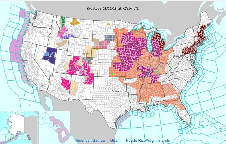
Dangerous Daytime Highs
Temperatures are expected to push into the 90s. When combined with the high humidity left behind by Monday's storms, the "feels like" heat indices could dangerously spike between 105 and 115 degrees across the broader region.
No Overnight Relief
The NWS specifically warns that overnight cooling will be severely limited, with lows stalling out in the mid-to-upper 70s. When homes and infrastructure can't cool down at night, the risk of heat-related illness skyrockets for vulnerable populations.
The NWS has classified the central and eastern U.S. under a "Moderate to Major" HeatRisk for Monday, escalating to "Major to Extreme" by Tuesday.
Stay safe, stay cool, and check on your neighbors.
The Local Connection: Why We Build "Resiliency" Plans
When the city talks about "Climate Action and Resiliency," they aren't just using buzzwords—they are trying to figure out how to physically and financially survive weeks exactly like this one.
Look at how this week's NWS forecast directly targets the city's key action pillars:
- Stormwater Management: Upgrading our municipal drainage to prevent the exact flash-flooding the NWS is warning about today.
- Tree Canopy & Urban Heat: Expanding shaded green spaces in commercial areas to combat the trapped, radiant heat we will experience on Tuesday.
- Energy Efficiency: Fortifying the municipal grid so it doesn't fail when thousands of West Metro air conditioners are running at maximum capacity overnight.
And if you haven't yet, take a few minutes to review the city's proposed resiliency blueprint and log your feedback before the July 15 deadline. The weather isn't waiting—and neither should our infrastructure.
NOAA NWS Heat Index Danger Levels
NWS Heat Index combines air temperature and relative humidity to determine the "feels like" apparent temperature. Prolonged exposure or physical activity in these ranges significantly increases the risk of heat disorders.
- Caution (80°F – 90°F)
- Risk: Fatigue possible with prolonged exposure and/or physical activity.
- Apparent Temperature Example: 84°F air temperature at 70% humidity.
- Extreme Caution (91°F – 103°F)
- Risk: Heat cramps and heat exhaustion possible with continued exposure.
- Apparent Temperature Example: 90°F air temperature at 50% humidity.
- Danger (103°F – 124°F)
- Risk: Heat cramps or heat exhaustion likely; heat stroke possible with continued activity.
- Apparent Temperature Example: 98°F air temperature at 45% humidity.
- Extreme Danger (125°F and higher)
- Risk: Heat stroke is highly imminent.
- Apparent Temperature Example: 100°F air temperature at 60% humidity.
Important Considerations
- Direct Sunlight: Exposure to full sunshine can increase the heat index values by up to 15° F.
- Local Alerts: The NWS generally initiates Excessive Heat Watch and Advisory procedures when the Heat Index is expected to exceed 105° F to 110° F (depending on your local climate) for at least two consecutive days

 Plymouth Editorial
We are here to fill the void between the mainstream media and social media; to create a hyperlocal publication focused on the West Metro.


